How to choose the right Ubaye route, depending on the water levels?
En fonction de la saison et de la météo, l’Ubaye change d’intensité et les formules eaux vives que nous proposons : descente découverte, sport etc.. changent aussi. Nous adaptons le niveau de difficulté avec les différents parcours de la rivière.
Nous allons vous expliquer l’évolution des niveaux de difficultés des parcours, selon la saison. Nous parlons là de portions de rivière. Cette page est indicative : ce sont les guides qui choisissent the right route, adapted to your desires, and to the conditions of the river on the day.
If you wish comprendre les choix des parcours en fonction des niveaux d’eau, voici les indications que nous mettons à disposition :
- A detailed description of all the routes and their landscapes
- An explanation of the variations of the river, depending on the seasons
- Route selection tables based on water levels
NB: It is important to understand that this information is unofficial, and that it is the result of the experiences of our Crazy Water rafting guides. We are talking about a natural river and therefore a living element. There is no exact science when it comes to living water.
If you would like more information, do not hesitate to contact us by telephone at 06.87.53.87.98. You can reach us 7 days a week from 8 a.m. to 9 p.m.
Variations in the flow of the Ubaye River
Il y a trois éléments à connaître pour comprendre les niveaux d’eaux :
- La période de snowmelt : La source de l’Ubaye est à 2900 mètres d’altitude. C’est un stock de neige qui fond progressivement, à partir du printemps. Plus nous avons de la neige en altitude, plus les niveaux d’eaux vont être important au printemps et en été.
- Les températures : Quand les températures sont hautes, la fonte des neiges s’accélère et le niveau d’eau monte. Si les températures baissent, le débit baisse aussi car la neige fond moins vite en altitude.
- Les pluies : au cours des précipitations le débit augmente, mais la rivière retourne à son niveau de saison rapidement. C’est l’effet « chasse d’eau ». Cela dure en moyenne une journée.
The choice of routes depending on the flow of the river
We calculate the water flow in cubic meters per second via the service vigicrue weather France
Here is a reference table of the choice of routes, for the Crazy Water rafting base
Water levels for the rafting activity
| Water flow measurement | Baby raft | Discovery Rafting Best of | Rafting Sports | Extreme Rafting |
|---|---|---|---|---|
| From 5 to 30 m3 second | Thuile-Fresquiere | Martinet-Lauzet | Ex from the Top | Ex from the bottom |
| From 30 to 50m3 second | Condamine-Jausiers | Thuiles-Fresquiere Martinet-Lauzet | Martinet-Lauzet | |
| From 50 to 70m3 second | Thuiles-Fresquiere | Martinet-Lauzet | ||
| More than 70m3 second | Thuiles-Fresquiere Condamine-Jausiers | Thuiles-Fresquiere | Bachelard |
Water levels for the Hydrospeed activity
En dessous de 6m3 seconde, l’hydrospeed n’est pas praticable sur l’Ubaye. Il n’y a plus assez d’eau par rapport à la vitesse du courant et le pratiquant touche trop le fond de la rivière.
| Water flow measurement | Hydrospeed Family Initiation | Hydrospeed Discovery | Hydrospeed Sport |
|---|---|---|---|
| From 6 to 20 m3 second | Martinet-Lauzet | Martinet-Lauzet | Ex from the Top |
| From 20 to 50m3 second | Condamine-Jausiers Thuiles-Fresquiere | Thuiles-Fresquiere | Martinet-Lauzet |
Water levels for the Kayak activity airboat and Hotdog (inflatable kayaks)
Above 20m3 second, the inflatable kayak is no longer passable on the Ubaye river. The boat is not suitable for big waves because the kayak is self-bailing up to a certain level.
| Water flow measurement | Kayaking Family Initiation | Discovery Kayak | Kayak Sports |
|---|---|---|---|
| From 4 to 10 m3 second | Martinet-Lauzet | Martinet-Lauzet | Ex from the Top |
| From 10 to 20m3 second | Condamine-Jausiers Thuiles-Fresquiere | Thuiles-Fresquiere | Martinet-Lauzet |
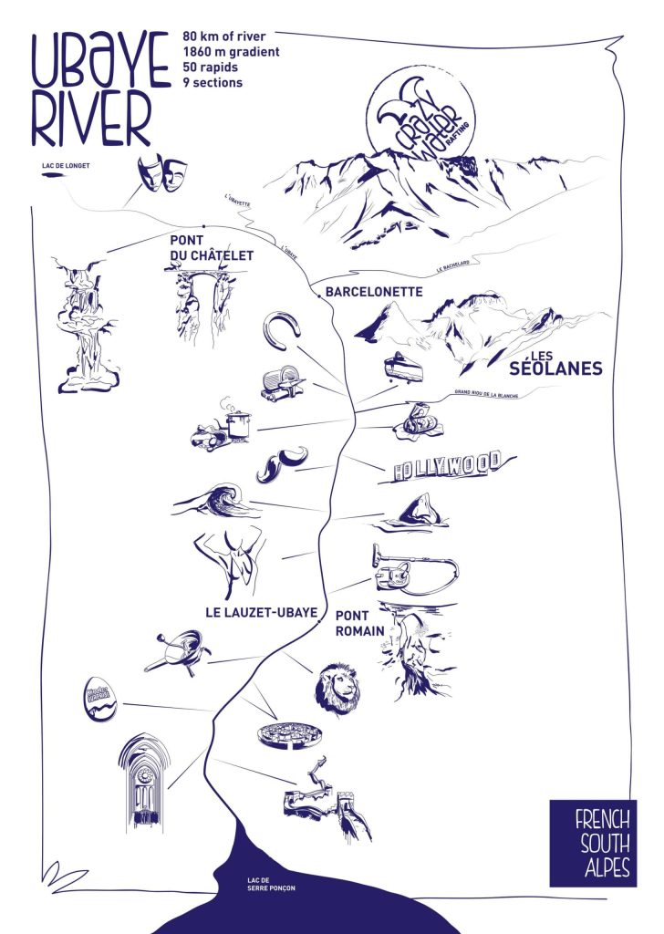
The Ubaye river ROUTES
Nous allons partir de la source de l’Ubaye, jusqu’au Serre Ponçon Lake, où l’Ubaye se termine.
Upper Ubaye
Les gorges de Saint Paul sur Ubaye (classe V) : C’est une partie de la rivière très étroite, avec des chutes d’eau. Elle est praticable seulement au printemps, par des kayakistes chevronnés, en kayak de rivière (kayak plastique avec jupe). Ce parcours n’est pas commercial.
The Bachelard (classe IV-V)
Naviguez sur un affluent de l’Ubaye . Petit trésor de navigation, ce parcours évolue dans une milieu sauvage. Il faut descendre le raft à la corde pour accéder à la rivière. Descente technique, elle se fait uniquement au printemps, quand le Bachelard est en crue.
Condamine – Jausiers (class II-III)
Très sauvage, la rivière traverse la forêt de Mélèze, entouré de montagnes abruptes. Vous verrez le Fort de Tournoux, spectaculaire monument historique, creusé dans la roche. Deux rapides à sensations sont à franchir et le reste du parcours est large et paisible.
From Jausiers to Thuiles
C’est le canal qui traverse Barcelonnette. Il n’y a pas d’activités eaux vives.
Tiles – Fresquière (class III)
Nous commençons à entrer dans le « vive » du sujet ! Le démarrage se fait dans le rapide des Thuiles ; un vrai beau rapide manœuvrier et plutôt long. Puis le reste du parcours est joueur, avec le rapide du Rioclar et ses belles vagues.
Lower Ex or Lower Infrant Ex (class V)
Entre les hameaux de la Fresquière et du Martinet, c’est un enchaînement de rapides, très techniques avec des petites chutes. Ce parcours est exigent et demande une vrai connaissance de la navigation en rivière. Au printemps, ce parcours est infranchissable sauf pour les kayakistes extrêmes (en kayak plastique avec jupe). En été, lorsque les niveaux d’eau sont bon c’est un terrain de jeu extraordinaire pour les sportifs.
Martinet-Lauzet or Meuleu (class IV)
THE parcours « mythique » de l’Ubaye. C’est le parcours le plus long en terme de kilomètres et le plus varié au niveau des paysages. Vous démarrez dans la vallée de Barcelonnette, large et verdoyante. Puis une ambiance plus minérale, avec le lit de la rivière qui se ressert. Et pour terminer dans les gorges très étroites du Lauzet. Vous passez sous le Pont Roman, monument historique dans la Vallée. Une 15enes de rapides se suivent tout au long de la descente.
Lower Ex or Lower Infringent Ex (class V+)
Du lieu dit la source au Lauzet, jusqu’au lac de Serre Ponçon. C’est un parcours extrême qui est rarement accessible en commercial. Il est splendide avec des enchaînements de gros rapides au milieu des gorges étroites. Il est infranchissable durant les grosses crues. C’est le parcours préférer de l’équipe de crazy water rafting Ubaye
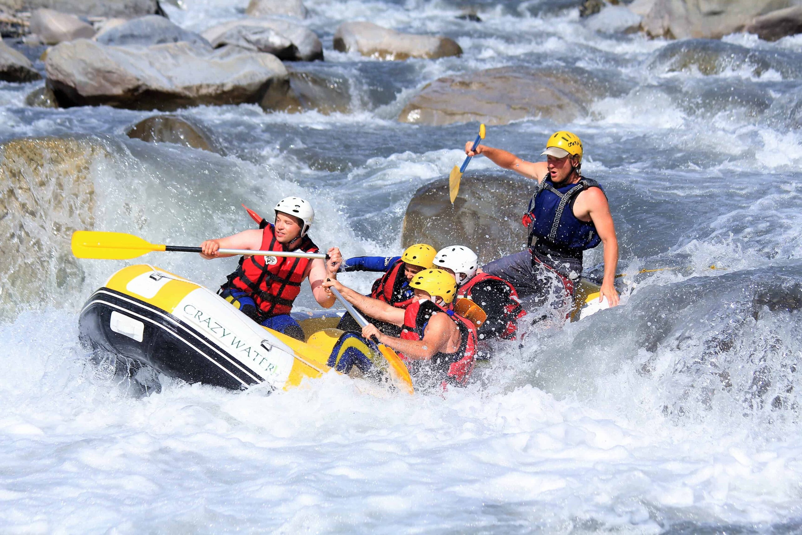
Can a flood be dangerous when rafting?
Yes and no
For la pratique commerciale du rafting, c’est-à-dire quand nous prenons la responsabilité professionnelle d’emmener des gens sur la rivière, la réponse est non ! Tout les facteurs risques sont analysés et maîtrisés par le guide de rivière qui vous accompagne.
Il faut savoir que les guides de l’Ubaye ont reçu une formation spéciale, pour ce genre de rivières de classe III à V. C’est un diplôme de guide de haute rivière. Et c’est en acquièrent de l’expérience, que le guide choisit d’aller dans des parcours sports ou extrêmes .
As a practitioner of a whitewater activity, zero risk does not exist, like all outdoor activities. As zero risk does not exist in skiing or sea surfing etc…
Yes, a flood can be dangerous, because of the waste that the river can carry: trees, iron installation carcasses too close to the river bed, etc. they can get stuck in a rapid, on an essential passage of the raft or 'another boat. In personal practice, the extreme kayaker must be very vigilant. In a commercial context, the guides and the various Ubaye rafting bases are well informed and know the places to avoid on the big day.
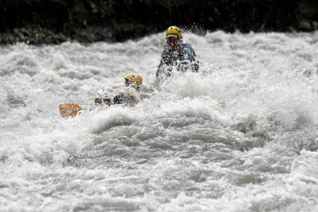
Is rafting dangerous when it rains?
Non ! Durant une pluie, même forte, le niveau d’eau ne monte presque pas. La descente reste la même et mouillé pour mouillé, le rafting se pratique très bien quand il pleut. Il n’y a pas de risque d’éclaire car ce phénomène météo reste au sommet des montagnes, et non pas en font de vallée. De plus, vous êtes sur une embarcation en plastique sur l’eau, donc pas de danger .
The same goes for hydrospeed and inflatable kayaking which are practiced very well in the rain.
Par contre, le canyoning est une activité qui ne se pratique pas quand il pleut. Vous évoluez dans des vasques d’eau et des cascades, donc le niveau d’eau peut vite monter. Il y a aussi le risque de trop glisser sur les rochers. Donc s’il pleut et que le canyoning est annulé, venez faire du rafting !
Si vous désirez en savoir plus sur la rivière de l’Ubaye, nous serons heureux de répondeur à toute vos questions sur notre base de Crazy Water rafting !